Fire Ban in Effect (April 23)

A FIRE BAN is issued for Lamont County effective April 23, 2024, at 2:30 p.m. - NEW Off-Highway Restriction and any type of outside burning is prohibited until further notice.

Rural Addressing

Downloadable Information

FAQs (Rural Addressing)  


Click on the titles below to open documents related to our Rural Addressing Program.

The following is a listing of the most frequently asked questions regarding our rural addressing program. 

1. What is rural addressing and why do we need it?

Rural Addressing is a standardized system of identifying and locating rural properties. This system will aid emergency response personnel, such as fire, ambulance, and police, in finding your house in the case of an emergency.

2. What are the benefits of using rural addresses over a legal land location?

A legal land location can tell you that a property is located somewhere on a specific quarter, but a rural address will pinpoint the access to the property off of a range road or township road. The addressing system is easy to use and understand if you follow a few simple rules. In an emergency, a reduced response time can mean the difference between life and death.

3. How are rural addresses created?

The governing municipality assigns rural addresses. A typical urban or city address is based off the street and avenue road network. Similarly, a rural address if based on the access point into a property off of the township road and range road network. In this example (270038 Twp Rd 380), we can tell that the access point to this property is on the north side of Township Road 380, 1520 meters west of Range Road 270.

4. Is the Rural Address the same as the Mailing Address?

No. Your current Canada Post mailing address will not change. Continue to use your existing mailing address to send and receive postal correspondences.

5. I already have a Rural Address from Elk Island Public Schools (EIPS). Will it change?

Unfortunately yes it will, Lamont County is working closely with EIPS in order to make sure that the new Rural Addresses will be reflected in their records to avoid any conflicts with bus routes.

6. How do I get my Rural Address?

Your new Rural Address will be provided to you. The information will be provided at the time of sign installation. After that, any new subdivisions or developments will require the owner or developer to request the Rural Address from the county, as part of the development process, through the Planning and Development Department.

7. Is rural addressing new to Alberta?

No. Many Alberta rural municipalities have implemented rural addressing, such as Lacombe County, Yellowhead County, Clearwater County, Beaver County, Sturgeon County and Strathcona County. to name a few. More and more municipalities are implementing rural addressing each year.

8. Who assigns the Rural Addresses?

Rural Addressing information has been initially assigned and maintained by the Lamont County GIS Department. In the future Lamont County will be assigning addresses to new Subdivisions and development . All the addressing has been shared with Telus for use with the 911systems. When an owner or developer requires a Rural Address for a new development, they will request the information through the Development and Planning Department as a standard step in the development process.

9. What do I do with my new Rural Address once I get it?

Remember, your new Rural Address is primarily for emergency response. The best use of your rural address will be to memorize the number so if you need to use 911, you can give the 911 dispatcher the number. It is recommended to have your Rural address posted by every phone in your house. Also be sure to educate your children as to what your Rural Address is, what it is for, and how it should be used in the event of an emergency.

10. Who is responsible for the maintenance and upkeep of the Rural Address Signs?

The property owner, signage is a crucial element in the assurance of quick emergency response. It is in the best interest of the property owner or residence that the address sign is displayed in the proper location.

11. How do I find my location (Pin Drop) with Google Maps?

1. Open a Web Browser such as Internet Explorer, Chrome, Safari, or Firefox.

2. In the URL section at the top of the browser, type in www.google.com/maps

map_1

3. Your location should be indicated by a blue dot! Skip to step 5 to see how to place a Pin and share it. If you do not see the blue dot, or your location is incorrect, refer to step 4.
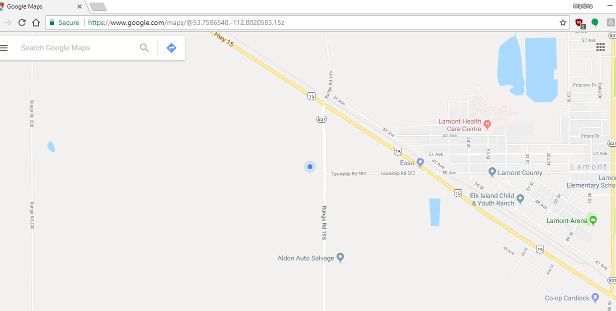
map_2

4. To help find your gps coordinates, you can use the search box at the top left corner to search for a nearby road or town. Once typed in, press the magnifying glass to display the location. You can then move the map to your desired location by left-clicking on the map, holding down the left-mouse button, and dragging it down or up.

5. To share a location, press down on the left-mouse button over the area you wish to tag for 3 seconds, and then release. At the bottom of the map, a box will appear with the coordinates of your chosen location.

6. Click on the gps coordinates to bring up a list of options on the left hand of the screen.

7. Click on the Share button to generate a link.

8. Press Copy Link to copy the url to your clipboard. You can now right click and paste this link into an email, document, or other web browser.